The
history of Mumbai deals with the growth of a collection of
seven islands on the west coast of India to become the commercial capital of the nation, and one of the most
populous cities in the world. Although human habitation existed since the
Stone Age, the
Kolis, a marathi fishing community,
[1] were the earliest known settlers of the islands. The
Maurya Empire gained control of the islands during the 3rd century BCE, and transformed it into a centre of
Hindu and
Buddhist culture and religion. Later, between the 2nd century BCE and 9th century CE, the islands came under the control of successive
indigenous dynasties:
Satavahanas,
Abhiras,
Vakatakas,
Kalachuris, Konkan Mauryas,
Chalukyas and
Rashtrakutas, before being ruled by the
Silharas from 810 to 1260.
King Bhimdev established his kingdom in the region in the late 13th century, and brought many settlers to the islands. The Muslim rulers of
Gujaratcaptured the islands in 1348, and they were later governed by the
Gujarat Sultanate from 1391 to 1534. The
Treaty of Bassein between the Portuguese viceroy
Nuno da Cunha and
Bahadur Shah of the Gujarat Sultanate placed the islands into Portuguese possession in 1534.
The islands suffered incursions from
Mughals towards the end of the 17th century. During the mid-18th century, the city emerged as an important trading town, with maritime trade contacts with
Mecca and
Basra. Economic and educational development characterised the city during the 19th century with the first-ever Indian railway line beginning operations between Mumbai and neighbouring
Thane in 1853. The city became a strong base for the
Indian independence movement during the early 20th century and was the epicentre of the
Rowlatt Satyagraha of 1919 and
Royal Indian Navy Mutiny of 1946. After
India's independence in 1947, the territory of Mumbai Presidency retained by India was restructured into
Mumbai State. The area of Mumbai State increased, after several erstwhile princely states that joined the Indian union were integrated into Mumbai State.
Early history
Pre-historic period

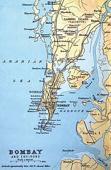
The seven islands of Mumbai with their anglicised names
Geologists believe that coast of western India came into being around 100 to 80
mya after it broke away from Madagascar. Soon after its detachment, the peninsular region of the Indian plate drifted over the
Réunion hotspot, a volcanic hotspot in the Earth's lithosphere near the island of
Réunion. An eruption here some 66 mya is thought to have laid down the
Deccan Traps, a vast bed of
basalt lava that covers parts of central India. This volcanic activity resulted in the formation of basaltic outcrops, such as the
Gilbert Hill, that are seen at various locations in the city. Further
tectonic activity in the region led to the formation of hilly islands separated by a shallow sea.
[3] Pleistocene sediments found near
Kandivaliin northern Mumbai by British archaeologist Todd in 1939 indicate habitation since the
Stone Age. The present day city was built on what was originally an archipelago of
seven islands of
Bombay Island,
Parel,
Mazagaon,
Mahim,
Colaba,
Worli, and
Old Woman's Island (also known as
Little Colaba).The islands were coalesced into a single landmass by the
Hornby Vellard engineering project in 1784. By 1000 BCE, the region was heavily involved in seaborne commerce with Egypt and
Persia.The
Koli fishing community had long inhabited the islands.They were
Dravidian in origin and included a large number of scattered tribes along the
Vindhya Plateau, Gujarat, and
Konkan. In Mumbai, there were three or four of these tribes. Their religious practices could be summed up as
animism.
Age of indigenous empires
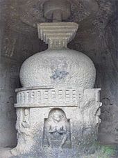
Kanheri Caves served as a centre of Buddhism during ancient times
The islands were incorporated into the
Maurya Empire under Emperor
Ashoka of
Magadha in the third century BCE. The empire's patronage made the islands a centre of
Hindu and
Buddhist religion and culturE.Buddhist monks, scholars, and artists created the artwork, inscriptions, and sculpture of the
Kanheri Caves in the mid third century BCE and
Mahakali Caves. After the decline of the Maurya Empire around 185 BCE, these islands fell to the
Satavahanas.The port of
Sopara (present-day
Nala Sopara) was an important trading centre during the first century BCE, with trade contacts with Rome. The islands were known as
Heptanesia(
Ancient Greek: A Cluster of Seven Islands) to the Greek geographer
Ptolemy in 150 CE. After the end of the Satvahana rule in 250 CE, the
Abhiras of Western Maharashtra and
Vakatakas of
Vidarbha held dominion over the islands. The Abhiras ruled for 167 years, till around 417 CE.The
Kalachuris of Central India ruled the islands during the fifth century,which were then acquired by the Mauryas of Konkan in the sixth and early part of the seventh century. The Mauryas were feudatories of Kalachuris, and the
Jogeshwari Caves were constructed during their regime between 520 and 525. The Greek merchant
Cosmas Indicopleustes visited
Kalyan (near Mumbai) during 530–550. The
Elephanta Caves also dates back to the sixth century. Christianity arrived in the islands during the sixth century, when the
Nestorian Church made its presence in India. The Mauryan presence ended when the
Chalukyas of
Badami in Karnataka under
Pulakeshin II invaded the islands in 610.
Dantidurga of the
Rashtrakuta Dynasty of Karnataka conquered the islands during 749–750.
The Silhara dynasty of Konkan ruled the region between 810 and 1260. The Walkeshwar Temple was constructed during the 10th century and the Banganga Tank during the 12th century under the patronage of the Silhara rulers. The Italian traveler Marco Polo's fleet of thirteen Chinese ships passed through Mumbai Harbour during May — September 1292. King Bhimdev founded his kingdom in the region in the late 13th century and established his capital inMahikawati (present day Mahim). He belonged to either the Yadava dynasty of Devagiri in Maharashtra or the Anahilavada dynasty of Gujarat. He built the first Babulnath temple in the region and introduced many fruit-bearing trees, including coconut palms to the islands.The Pathare Prabhus, one of the earliest settlers of the city, were brought to Mahim from Patan and other parts of Saurashtrain Gujarat around 1298 by Bhimdev during his reign.He is also supposed to have brought Palshis,Pachkalshis, Bhandaris,Vadvals, Bhois, Agris and Brahmins to these islands. After his death in 1303, he was succeeded by his son Pratapbimba, who built his capital at Marol in Salsette, which he named Pratappur. The islands were wrested from Pratapbimba's control by Mubarak Khan, a self-proclaimed regent of the Khilji dynasty, who occupied Mahim and Salsette in 1318. Pratapbimba later reconquered the islands which he ruled till 1331. Later, his brother-in-law Nagardev for 17 years till 1348. The islands came under the control of the Muslim rulers of Gujarat in 1348, ending the sovereignty of Hindu rulers over the islands.
Islamic period
The islands were under Muslim rule from 1348 to 1391. After the establishment of the
Gujarat Sultanate in 1391,
Muzaffar Shah I was appointed viceroy of north
Konkan.For the administration of the islands, he appointed a governor for
Mahim. During the reign of
Ahmad Shah I (1411–1443),
Malik-us-Sharq was appointed governor of Mahim, and in addition to instituting a proper survey of the islands, he improved the existing revenue system of the islands. During the early 15th century, the
Bhandaris seized the island of Mahim from the Sultanate and ruled it for eight years.It was reconquered by
Rai Qutb of the Gujarat Sultanate.
Firishta, a Persian historian, recorded that by 1429 the seat of government of the Gujarat Sultanate in north Konkan had transferred from
Thane to Mahim.On Rai Qutb's death in 1429–1430,
Ahmad Shah I Wali of the
Bahmani Sultanate of
Deccan captured Salsette and Mahim.
Ahmad Shah I retaliated by sending his son
Jafar Khan to recapture the lost territory. Jafar emerged victorious in the battle fought with Ahmad Shah I Wali. In 1431, Mahim was recaptured by the Sultanate of Gujarat.
[35] The Sultanate's patronage led to the construction of many mosques, prominent being the
Haji Ali Dargah in
Mahim, built in honour the Muslim saint
Haji Ali in 1431. After the death of
Kutb Khan, the Gujarat commandant of Mahim, Ahmad Shah I Wali again despatched a large army to capture Mahim. Ahmad Shah I responded with a large army and navy under Jafar Khan leading to the defeat of Ahmad Shah I Wali.During 1491–1494, the islands suffered sea piracies from
Bahadur Khan Gilani, a nobleman of the
Bahamani Sultanate. After the end of the Bahamani Sultanate, Bahadur Khan Gilani and
Mahmud Gavan(1482–1518) broke out in rebellion at the port of
Dabhol and conquered the islands along with the whole of
Konkan. Portuguese explorer
Francisco de Almeida's ship sailed into the deep natural harbour of the island in 1508, and he called it
Bom baía (Good Bay). However, the Portuguese paid their first visit to the islands on 21 January 1509, when they landed at Mahim after capturing a Gujarat barge in the Mahim cret After a series of attacks by the Gujarat Sultanate, the islands were recaptured by
Sultan Bahadur Shah.
In 1526, the Portuguese established their factory at
Bassein. During 1528–29,
Lopo Vaz de Sampaio seized the fort of Mahim from the Gujarat Sultanate, when the King was at war with Nizam-ul-mulk, the emperor of
Chaul, a town south of the islands.
[43][44][45] Bahadur Shah had grown apprehensive of the power of the
Mughal emperor
Humayun and he was obliged to sign the
Treaty of Bassein with the Portuguese on 23 December 1534. According to the treaty, the islands of Mumbai and Bassein were offered to the Portuguese. Bassein and the seven islands were surrendered later by a treaty of peace and commerce between Bahadur Shah and
Nuno da Cunha, Viceroy of
Portuguese India, on 25 October 1535, ending the Islamic rule in Mumbai.
Portuguese period

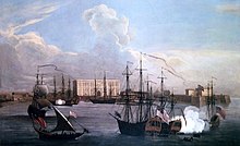
Davies' sketch of Bombay harbour 1626
The Portuguese were actively involved in the foundation and growth of their religious orders in Bombay. The islands were leased to
Mestre Diogo in 1534. The
San Miguel (
St. Michael Church) in
Mahim, one of the oldest churches in Bombay, was built by the Portuguese in 1540.
Parel,
Wadala,
Sion, and
Worli were granted to
Manuel Serrão between 1545 and 1548, during the viceroyalty of
João de Castro.
Mazagaon was granted to
Antonio Pessoa in 1547.
Salsette was granted for three years to
João Rodrigues Dantas,
Cosme Corres, and
Manuel Corres.
Trombay and
Chembur were granted to
Dom Roque Tello de Menezes, and the Island of Pory (
Elephanta Island) to
João Pirez in 1548.
Garcia de Orta, a Portuguese physician and botanist, was granted the possession of Bombay in 1554 by viceroy
Pedro Mascarenhas.
The Portuguese encouraged intermarriage with the local population, and strongly supported the Roman Catholic Church. In 1560, they started proselytising the local
Koli,
Kunbi,
Kumbhar population in
Mahim,
Worli, and Bassei These Christians were referred to by the British as
Portuguese Christians, though they were Nestorian Christians who had only recently established ties with the Roman Catholic Church. During this time, Bombay's main trade was coconuts and coir. After
Antonio Pessoa's death in 1571, a patent was issued which granted
Mazagaon in perpetuity to the
Sousa e Lima family. The
St. Andrew Church at Bandra was built in 1575.
The annexation of Portugal by
Spain in 1580 opened the way for other European powers to follow the spice routes to India. The
Dutcharrived first, closely followed by the British.
[57] The first English merchants arrived in Bombay in November 1583, and travelled through Bassein,
Thane, and
Chaul The Portuguese Franciscans had obtained practical control of Salsette and Mahim by 1585, and built
Nossa Senhora de Bom Concelho (Our Lady of Good Counsel) at Sion and
Nossa Senhora de Salvação (Our Lady of Salvation) at
Dadarin 1596. The
Battle of Swally was fought between the British and the Portuguese at
Surat in 1612 for the possession of Bombay.
[45] Dorabji Nanabhoy, a trader, was the first
Parsi to settle in Bombay in 1640.
Castella de Aguada (Fort of the Waterpoint) was built by the Portuguese at Bandra in 1640 as a watchtower overlooking the
Mahim Bay, the
Arabian Sea and the southern island of Mahim.
] The growing power of the
Dutch by the middle of the seventeenth century forced the Surat Council of the British Empire to acquire Bombay from
King John IV of Portugal in 1659.The marriage treaty of
Charles II of England and
Catherine of Portugal on 8 May 1661 placed Bombay in British possession as a part of Catherine's dowry to Charles.
British period

Map of Port and Island of Bombay with the adjacent islands, 1724
Struggle with native power
On 19 March 1662,
Abraham Shipman was appointed the first Governor and General of the city, and his fleet arrived in Bombay in September and October 1662. On being asked to hand over
Bombay and
Salsette to the English, the Portuguese Governor contended that the island of Bombay alone had been ceded, and alleging irregularity in the patent, he refused to give up even Bombay. The Portuguese
Viceroydeclined to interfere and Shipman was prevented from landing in Bombay. He was forced to retire to the island of
Anjediva in
North Canara and died there in October 1664. In November 1664, Shipman's successor
Humphrey Cooke agreed to accept Bombay without its dependencies. However,
Salsette,
Mazagaon,
Parel,
Worli,
Sion,
Dharavi, and
Wadala still remained under Portuguese possession. Later, Cooke managed to acquire Mahim, Sion, Dharavi, and Wadala for the English.
[63] On 21 September 1668, the
Royal Charter of 27 March 1668, led to the transfer of Bombay from Charles II to the
English East India Company for an annual rent of
£10 (equivalent
retail price index of £1,226 in 2007). The Company immediately set about the task of opening up the islands by constructing a quay and warehouses. A customs house was also built. Fortifications were built around
Bombay Castle. A Judge-Advocate was appointed for the purpose of civil administration.
] George Oxenden became the first Governor of Bombay under the English East India Company on 23 September 1668.
Gerald Aungier, who was appointed Governor of Bombay in July 1669, established the first mint in Bombay in 1670. He offered various business incentives, which attracted
Parsis,
Goans, Jews,
Dawoodi Bohras,
Gujarati Baniasfrom
Surat and
Diu, and
Brahmins from
Salsette. He also planned extensive fortifications in the city from
Dongri in the north to
Mendham's Point (near present-day
Lion Gate) in the south. The harbour was also developed during his governorship, with space for the berthing of 20 ships.n 1670, the Parsi businessman
Bhimjee Parikh imported the first printing press into Bombay.Between 1661 and 1675 there was a sixfold increase in population from 10,000 to 60,000.
[71] Yakut Khan, the
Siddiadmiral of the
Mughal Empire, landed at Bombay in October 1672 and ravaged the local inhabitants there. On 20 February 1673,
Rickloffe van Goen, the Governor-General of
Dutch India attacked Bombay, but the attack was resisted by Aungier.
] On 10 October 1673, the
Siddi admiral
Sambalentered Bombay and destroyed the Pen and Nagothana rivers, which were very important for the English and the
Maratha King
Shivaji.The
Treaty of Westminster concluded between England and the Netherlands in 1674, relieved the British settlements in Bombay of further apprehension from the Dutch. In 1686, the Company shifted its main holdings from
Surat to Bombay, which had become the administrative centre of all the west coast settlements then. Bombay was placed at the head of all the Company's establishments in India.

Remains of
Fort George, an extension built to the fortified walls of Bombay in 1769
Yakut Khan landed at
Sewri on 14 February 1689, and razed the
Mazagon Fort in June 1690. After a payment made by the British to
Aurangzeb, the ruler of the Mughal Empire, Yakut evacuated Bombay on 8 June 1690.The arrival of many Indian and British merchants led to the development of Bombay's trade by the end of the seventeenth century. Soon it was trading in salt, rice, ivory, cloth, lead and sword blades with many Indian ports as well as with the Arabian cities of
Mecca and
Basra. By 1710, the construction of
Bombay Castle was finished, which fortified the islands from sea attacks by European pirates and the Marathas. By 26 December 1715,
Charles Boone assumed the Governorship of Bombay. He implemented
Aungier's plans for the fortification of the island, and had walls built from
Dongri in the north to Mendham's point in the south
] He established the Marine force,and constructed the
St. Thomas Cathedral in 1718, which was the first
Anglican Church in Bombay. In 1728, a Mayor's court was established in Bombay and the first reclamation was started which was a temporary work in
Mahalaxmi, on the creek separating Bombay from
Worli.The shipbuilding industry started in Bombay in 1735 and soon the
Naval Dockyard was established in the same year.
In 1737, Salsette was captured from the Portuguese by Maratha Baji Rao I and the province of Bassein was ceded in 1739.] The Maratha victory forced the British to push settlements within the fort walls of the city. Under new building rules set up in 1748, many houses were demolished and the population was redistributed, partially on newly reclaimed land. Lovji Nusserwanjee Wadia, a member of the Wadia family of shipwrights and naval architects from Surat, built the Bombay Dock in 1750, which was the first dry dock to be commissioned in Asia. By the middle of the eighteenth century, Bombay began to grow into a major trading town and soon Bhandaris from Chaul in Maharashtra, Vanjaris from the Western Ghat mountain ranges of Maharashtra, Africans from Madagascar, Bhatias from Rajasthan, Vaishya Vanis, Goud Saraswat Brahmins, Daivajnas from konkan, ironsmiths and weavers from Gujarat migrated to the islands In 1769,Fort George was built on the site of the Dongri Fort and in 1770, the Mazagaon docks were built. The British occupied Salsette, Elephanta, Hog Island, and Karanja on 28 December 1774.Salsette, Elephanta, Hog Island, and Karanja were formally ceded to the British East India Company by the Treaty of Salbai signed in 1782, while Bassein and its dependencies were restored to Raghunathrao of the Maratha Empire.[91] Although Salsette was under the British, but the introduction of contraband goods from Salsette to other parts of Bombay was prevented. The goods were subjected to Maratha regulations with respect to taxes and a 30% toll was levied on all goods into the city from Salsette.
In 1782, William Hornby assumed the office of Governor of Bombay, and initiated the Hornby Vellard engineering project of uniting theseven islands into a single landmass. The purpose of this project was to block the Worli creek and prevent the low-lying areas of Bombay from being flooded at high tide.[89] However, the project was rejected by the British East India Company in 1783. In 1784, the Hornby Vellard project was completed and soon reclamations at Worli and Mahalaxmi followed.The history of journalism in Bombay commenced with publication of the Bombay Herald in 1789 and the Bombay Courier in 1790. In 1795, the Maratha army defeated theNizam of Hyderabad. Following this, many artisans and construction workers from Andhra Pradesh migrated to Bombay and settled into the flats which were constructed by the Hornby Vellard. These workers where called Kamathis, and their enclave was calledKamathipura. The construction of the Sion Causeway (Duncan Causeway) commenced in 1798. The construction of the Sion Causeway was completed in 1802 by Governor Jonathan Duncan. It connected Bombay Island to Kurla in Salsette. On 17 February 1803, a fire raged through the town, razing many localities around the Old Fort, subsequently the British had to plan a new town with wider roads. In May 1804, Bombay was hit by a severe famine, which led to a large-scale emigration. On 5 November 1817, the British East India Company under Mountstuart Elphinstone defeated Bajirao II, the Peshwa of the Maratha Empire, in the Battle of Kirkee which took place on the Deccan Plateau.The success of the British campaign in the Deccan witnessed the freedom of Bombay from all attacks by native powers.
City development
The educational and economic progress of the city began with the Company's military successes in the Deccan. The
Wellington Pier(Apollo Bunder) in the north of
Colaba was opened for passenger traffic in 1819 and the
Elphinstone High School was established in 1822. Bombay was hit by a water famine in 1824. The construction of the new mint commenced in 1825.
[66] With the construction of a good carriage road up the
Bhor Ghat during the regimes of
Mountstuart Elphinstone and
Sir John Malcolm gave better access from Bombay to the Deccan. This road, which was opened on 10 November 1830, facilitated trade in a large measure.
[102] By 1830, regular communication with England started by steamers navigating the
Red and
Mediterranean Sea. In July 1832, the Parsi riots took place in consequence of a Government order for the destruction of pariah dogs which infested the city. The
Asiatic Society of Bombay (Town Hall) was completed in 1833, and the
Elphinstone College was built in 1835. In 1836, the Chamber of Commerce was established.
In 1838, the islands of
Colaba and
Little Colaba were connected to Bombay by the
Colaba Causeway In the same year, monthly communication was established between Bombay and London.The
Bank of Bombay, the oldest bank in the city, was established in 1840, and the Bank of Western India in 1842.The Cotton Exchange was established in
Cotton Green in 1844.
Avabai Jamsetjee Jeejeebhoy funded the construction of the
Mahim Causeway to connect
Mahim to
Bandra and the work was completed in 1845. The
Commercial Bank of India, established in 1845, issued exotic notes with an interblend of Western and Eastern Motifs. On 3 November 1845, the
Grant Medical College and hospital, the third in the country, was founded by Governor
Robert Grant The earliest riots occurred at
Mahim in 1850, in consequence of a dispute between two rival factions of Khojas. Riots broke out between Muslims and
Parsis in October 1851, in consequence of an ill-advised article on
Prophet Muhammad which appeared in the
Chitra Gnyan Darpan newspaper. The first political organization of the
Bombay Presidency, the Bombay Association, was started on 26 August 1852, to vent public grievances to the British.
[110] The first-ever Indian railway line began operations between Bombay and neighbouring
Thane over a distance of 21 miles on 16 April 1853. The
Bombay Spinning and Weaving Company was the first
cotton mill to be established in the city on 7 July 1854 at
Tardeo in Central Bombay. The
Bombay, Baroda, and Central India Railway (BB&CI) was incorporated in 1855.
The University of Bombay was the first modern institution of higher education to be established in India in 1857.[The Commercial Bank, the Chartered Mercantile, the Agra and United Service, the Chartered and the Central Bank of Western India were established in Bombay attracting a considerable industrial population. The outbreak of the American Civil War in 1861 increased the demand for cotton in the West, and led to an enormous increase in cotton-trade. TheVictoria Gardens was opened to the public in 1862. The Bombay Shipping and Iron Shipping Companies were started in 1863 to make Bombay merchants independent of the English. TheBombay Coast and River Steam Navigation Company was established in 1866 for the maintenance of steam ferries between Bombay and the nearby islands; while the opening of theSuez Canal in 1869 revolutionized the marine trade of Bombay. The Bombay Municipal Corporation was established in 1872, providing a modern framework of governance for the rapidly growing city. The Bombay Port Trust was promulgated in 1870 for the development and administration of the port. Tramway communication was instituted in 1873. The Bombay Electric Supply and Transport (BEST), originally set up as a tramway company: Bombay Tramway Company Limited, was established in 1870Violent Parsi-Muslim riots again broke out in February 1874, which were caused by an article on Prophet Muhammad published by a Parsi resident. The Bombay Gymkhana was formed in 1875. The Bombay Stock Exchange, the oldest stock exchange in Asia, was established in 1875. Electricity arrived in Bombay in 1882 and Crawford Market was the first establishment to be lit up by electricity.[124]The Bombay Natural History Society was founded in 1883.Bombay Time, one of the two official time zones in British India, was established in 1884 during theInternational Meridian Conference held at Washington, D.C in the United States. Bombay time was set at 4 hours and 51 minutes ahead of Greenwich Mean Time (GMT) using the 75th east meridian The Princess Dock was built in 1885 as part of a scheme for improving the whole foreshore of the Bombay harbour.
Indian freedom movement
The growth of political consciousness started after the establishment of the Bombay Presidency Association on 31 January 1885. The Bombay Millowners' Association was formed in February 1875 by
Dinshaw Maneckji Petit in order to
lourdes central school protect interests of workers threatened by possible factory and tariff legislation by the British. The first session of the
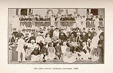
Indian National Congresswas held in Bombay from 28–31 December 1885. The Bombay Municipal Act was enacted in 1888 which gave the British Government wide powers of interference in civic matters. The
Victoria Terminus of the
Great Indian Peninsular Railway, one of the finest stations in the world, was completed in May 1888. The concept of
Dabbawalas (lunch box delivery man) originated in the 1890s when British people who came to Bombay did not like the local food. So the
Dabbawala service was set up to bring lunch to these people in their workplace straight from their home. On 11 August 1893, a serious communal riot took place between the Hindus and Muslims, when a
Shiva temple was attacked by Muslims in Bombay. 75 people were killed and 350 were injured. In September 1896, Bombay was hit by a
bubonic plague epidemic where the death toll was estimated at 1,900 people per week. Around 850,000, amounting to half of the population, fled Bombay during this time. On 9 March 1898, there was a serious riot which started with a sudden outbreak of hostility against the measures adopted by Government for suppression of plague. The riot led to a strike of dock and railway workers which paralysed the city for a few days.
[137] The significant results of the plague was the creation of the Bombay City Improvement Trust on 9 December 1898
[138] and the
Haffkine Institute on 10 January 1899 by
Waldemar Haffkine.
[139] The Dadar-Matunga-Wadala-Sion scheme, the first planned suburban scheme in Bombay, was formulated in 1899–1900 by the Bombay City Improvement Trust to relieve congestion in the centre of the town, following the plague epidemics. The cotton mill industry was adversely affected during 1900 and 1901 due to the flight of workers because of the plague.

The
Victoria Terminus in Bombay, one of the finest stations in the world, was completed in 1888
The
Partition of Bengal in 1905 initiated the
Swadeshi movement, which led to the boycotting of British goods in India.
[142] On 22 July 1908,
Lokmanya Tilak, the principal advocate of the Swadeshi movement in Bombay, was sentenced to six years rigorous imprisonment, on the charge of writing inflammatory articles against the Government in his newspaper
Kesari. The arrest led to huge scale protests across the city. The
Bombay Chronicle started by
Pherozeshah Mehta, the leader of the
Indian National Congress, in 1910, played an important role in the national movement until India's Independence.
Lord Willingdon convened the Provincial War Conference at Bombay on 10 June 1918, whose objective was to seek the co-operation of the people in the World War I measures which the British Government thought it necessary to take in the Bombay Presidency. The conference was followed by huge rallies across the city. The worldwide influenza epidemic raged through Bombay from September to December 1918, causing hundreds of deaths per day. The Lord Willingdon Memorial incident of December 1918 saw the handicap of Home Rulers in Bombay. The first important strike in the textile industry in Bombay began in January 1919. Bombay was the main centre of the
Rowlatt Satyagraha movement started by
Mahatma Gandhi from February — April 1919. The movement was started as a result of the
Rowlatt Act, which indefinitely extended emergency measures during World War I in order to control public unrest.

The
Gateway of India in Bombay, through which the last British troops left India on 28 February 1948
Following World War I, which saw large movement of India troops, supplies, arms and industrial goods to and from Bombay, the city life was shut down many times during the Non-cooperation movement from 1920 to 1922. In 1926, the Back Bay scandal occurred, when the Bombay Development Department under the British reclaimed the Back Bay area in Bombay after the financial crisis incidental to the post-war slump in the city. The first electric locomotives in India were put into service from Victoria Terminusto Kurla in 1925. In the late 1920s, many Persians migrated to Bombay from Yazd to escape the drought in Iran.[150] In the early 1930s, the nationwide Civil disobedience movement against the British Salt tax spread to Bombay. Vile Parle was the headquarters of the movement in Bombay under Jamnalal Bajaj. On 15 October 1932 industrialist and aviator J.R.D. Tata pioneered civil aviation in Bombay by flying a plane from Karachi to Bombay. Bombay was affected by the Great Depression of 1929, which saw a stagnation of mill industry and economy from 1933 to 1939. With World War II, the movements of thousands of troops, military and industrial goods and the fleet of the Royal Indian Navy made Bombay an important military base for the battles being fought in West Asia and South East Asia.[155] The climatic Quit India rebellion was promulgated on 7 August 1942 by the Congress in a public meeting at Gowalia Tank. The Royal Indian Navy Mutiny of 18 February 1946 in Bombay marked the first and most serious revolt by the Indian sailors of the Royal Indian Navy against British rule. On 15 August 1947, finally India was declared independent. The last British troops to leave India, the First Battalion of the Somerset Light Infantry, passed through the arcade of the Gateway of India in Bombay on 28 February 1948 ending the 282-year-long period of the British in Bombay .
Independent India
20th century
After the
Partition of India on 15 August 1947, over 100,000
Sindhi refugees from the newly created Pakistan were relocated in the military camps five kilometres from
Kalyan in the
Bombay metropolitan region. It was converted into a township in 1949, and named
Ulhasnagar by the then Governor-General of India,
C. Rajagopalachari. In April 1950, Greater Bombay District came into existence with the merger of Bombay Suburbs and Bombay City. It spanned an area of 235.1 km
2 (90.77 sq mi) and inhabited 2,339,000 of people in 1951. The
Municipal Corporation limits were extended up to
Jogeshwari along the
Western Railway and
Bhandup along the
Central Railway. This limit was further extended in February 1957 up to
Dahisar along the Western Railway and
Mulund on the Central Railway. In the 1955
Lok Sabha discussions, when
Bombay State was being re-organised along linguistic lines into the states of Maharashtra and
Gujarat, there was a demand from the
Congress, that the city be constituted as an autonomous city-state. But the
States Reorganisation Committee recommended a bi-lingual state for Maharashtra-
Gujarat, with Bombay as its capital. However, the
Samyukta Maharashtra movementopposed this, and insisted that Bombay be declared the capital of Maharashtra. The
Indian Institute of Technology Bombay was established in 1958 at
Powai, a northern suburb of Bombay. Following protests by the Samyukta Maharashtra movement in which 105 people were killed by police firing, Maharashtra State was formed with Bombay as its capital on 1 May 1960.
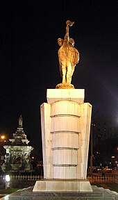
Flora Fountain was renamed
Hutatma Chowk ("Martyr's Square") as a memorial to the
Samyukta Maharashtra movement.
In the early 1960s, the
Gujarati and
Marwaris communities owned majority of the industry and trade enterprises in the city, while the white-collar jobs were mainly sought by the
South Indian migrants to the city. The
Shiv Sena party was established on 19 June 1966 by Bombay cartoonist
Bal Thackeray, out of a feeling of resentment about the relative marginalization of the native
Marathi people in their native state Maharashtra. In the 1960s and 1970s, Shiv Sena cadres became involved in various attacks against the South Indian communities, vandalising South Indian restaurants and pressuring employers to hire Marathis.
[168] In the late 1960s,
Nariman Point and
Cuffe Parade were reclaimed and developed. During the 1970 Bombay-
Bhiwandi riots, many Muslim places of worship were attacked by Shiv sena activists. During the 1970s, coastal communication increased between Bombay and south western coast of India, after introduction of ships by the London-based trade firm Shepherd. These ships facilitated the entry of
Goan and
Mangalorean Catholics to Bombay.
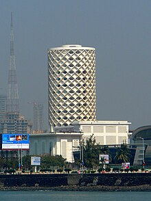
Nehru Centre was established in 1972 at
Worli in Bombay. The
Bombay Metropolitan Region Development Authority (BMRDA) was set up on 26 January 1975 by the
Government of Maharashtra as an apex body for planning and co-ordination of development activities in the
Bombay metropolitan region.
Nehru Science Centre, India's largest interactive science centre, was established in 1972 at Worli in Bombay.
[174] In August 1979, a sister township of
New Bombay was founded by
City and Industrial Development Corporation (CIDCO) across
Thane and
Raigad districts to help the dispersal and control of Bombay's population. The
Great Bombay Textile Strike was called on 18 January 1982 by trade union leader
Dutta Samant, where nearly 250,000 workers and more than 50
textile mills in Bombaywent on strike. On 17 May 1984, riots broke out in Bombay,
Thane, and
Bhiwandi after a saffron flag was placed at the top of a mosque. 278 were killed and 1,118 were wounded. The
Jawaharlal Nehru Port was commissioned on 26 May 1989 at
Nhava Shevawith a view to de-congest
Bombay Harbour and to serve as a hub port for the city. In December 1992 – January 93, over 1,000 people were killed and the city paralyzed by
communal riots between the Hindus and the Muslims caused by the destruction of the
Babri Mosquein
Ayodhya. A series of 13 co-ordinated
bomb explosions took place in Bombay on 12 March 1993, which resulted in 257 deaths and 700 injuries. The attacks were believed to be orchestrated by mafia don
Dawood Ibrahim in retaliation for the Babri Mosque demolition. In 1996, the newly elected
Shiv Sena-led government renamed the city of
Bombay to the native name
Mumbai, after the Koli Goddess
Mumbadevi. Soon colonial British names were shed to assert or reassert local names, such as Victoria Terminus being renamed to
Chhatrapati Shivaji Terminus on 4 March 1996, after the 17th century Marathi King
Shivaji.
21st century
During the 21st century, the city suffered several bombings. On 6 December 2002, a bomb placed under a seat of an empty BEST (
Brihanmumbai Electric Supply and Transport) bus exploded near
Ghatkopar station in Mumbai. Around 2 people were killed and 28 were injured. The bombing occurred on the tenth anniversary of the
demolition of the Babri Mosque in
Ayodhya.On 27 January 2003, a bomb placed on a bicycle exploded near the
Vile Parle station in Mumbai. The bomb killed 1 and injured 25. The blast occurred a day ahead of the visit of
Atal Bihari Vajpayee, the then
Prime Minister of India to the city. On 13 March 2003, a bomb exploded in a train compartment, as the train was entering the
Mulund station in Mumbai. 10 people were killed and 70 were injured. The blast occurred a day after the tenth anniversary of the
1993 Bombay bombings. On 28 July 2003, a bomb placed under a seat of a BEST bus exploded in Ghatkopar. The bomb killed 4 people and injured 32. On 25 August 2003, two blasts in
South Mumbai – one near the
Gateway of Indiaand the other at Zaveri Bazaar in
Kalbadevi occurred. At least 44 people were killed and 150 injured. No group claimed responsibility for the attack, but it had been hinted that the Pakistan-based
Lashkar-e-Toiba was behind the attacks.
Mumbai was lashed by torrential rains on
26–27 July 2005, during which the city was brought to a complete standstill. The city received 37 inches (940 millimeters) of rain in 24 hours — the most any Indian city has ever received in a single day. Around 83 people were killed. On 11 July 2006, a series of seven bomb blasts took place over a period of 11 minutes on the
Suburban Railway in Mumbai at
Khar,
Mahim,
Matunga,
Jogeshwari,
Borivali, and one between Khar and
Santa Cruz. 209 people were killed and over 700 were injured.
[195] According to
Mumbai Police, the bombings were carried out by
Lashkar-e-Toiba and
Students Islamic Movement of India (SIMI). In 2008, the city experienced
xenophobic attacks by the activists of the
Maharashtra Navnirman Sena (MNS) under
Raj Thackeray on the North Indian migrants in Mumbai. Attacks included assault on North Indian taxi drivers and damage of their vehicles. There were a series of
ten coordinated terrorist attacks by 10 armed Pakistani men using automatic weapons and grenades which began on 26 November 2008 and ended on 29 November 2008. The attacks resulted in 164 deaths, 308 injuries, and severe damage to several important buildings.The city again saw a series of
three coordinated bomb explosions at different locations on 13 July 2011 between 18:54 and 19:06 IST. The blasts occurred at the
Opera House,
Zaveri Bazaar, and
Dadar, which left 26 killed, and 130 injured. The city's
Wankhede Stadium was the venue for
2011 Cricket World Cup final, where
India emerged as a champion for the second time after the
1983 Cricket World Cup.
